
Esri IMGIS 2025: ACCA software at the GIS Event for Infrastructure
Esri IMGIS Returns April 9-11 - 2025: Discover How ACCA Software Integrates BIM and GIS to Enhance Infrastructure Design and Management with Geospatial Digital Twins

From April 9-11, 2025, Frankfurt, Germany will host the premier international conference exploring cutting-edge infrastructure management and geospatial solutions. This landmark event will unite global industry leaders, technological innovators, and experts to redefine urban infrastructure strategies through advanced GIS technologies.
ACCA Software, a pioneering force in openBIM® and a strategic partner of buildingSMART International, will showcase groundbreaking technological innovations, offering unprecedented insights into the future of infrastructure design and management.
Contents
What to Expect at the Esri IMGIS 2025 Event
The Esri International Infrastructure Management & GIS Conference is an international event that focuses on the application of geospatial technologies, particularly geographic information systems (GIS), in infrastructure management. This conference brings together professionals from various sectors, such as architecture, engineering, construction, energy, telecommunications, transportation, and water, to discuss best practices and the latest technologies in the field of infrastructure management.
The conference focuses on optimizing operations, organizational efficiency, and collaboration across projects through the use of ArcGIS technology.
The program includes plenary sessions, live demonstrations, presentations from partners and users, as well as networking activities. Key topics include BIM-GIS integration, network and facility management, environmental sustainability, and climate risk analysis.
Additionally, innovations such as digital twins and advanced artificial intelligence applications are presented.
Types of visitors
The event sees the participation of leading companies and technology partners such as Autodesk and ACCA software, along with industry experts who will share real case studies and innovative solutions.
How to be part of it
The conference will take place at the Kap Europa congress center in Frankfurt. To participate, you can register online through the official event website. Participants will have access to interactive sessions, technology exhibitions, and networking opportunities with industry professionals.
ACCA software’s BIM-GIS integration at Esri IMGIS
ACCA software, a sponsor of the event, will actively participate with a conference on April 9 at 2:15 PM, focusing on the integration of BIM and GIS through the use of technological innovations to extend the functionalities of the 3D environment of ArcGIS.
Specifically, ACCA will show how the integration of BIM and GIS can improve the design and management of infrastructures, creating “geospatial digital twins” useful for urban planning, resource management, and monitoring of infrastructure works. Through concrete examples of geospatial digital twins, it will be possible to discover how these technologies promote a more integrated and advanced approach to land design and maintenance.
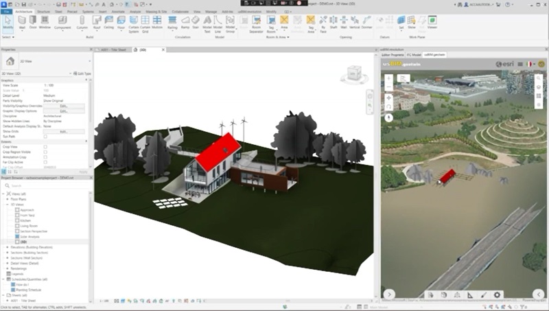
Creation of geospatial digital twins with dynamic integration between BIM models and GIS maps
This type of integration is essential because it allows for a more complete and accurate view of projects, improving collaboration among the various stakeholders in the sector, reducing errors and costs, and optimizing resource management. In this way, BIM and GIS technologies offer innovative solutions that promote a more sustainable and efficient management of public and private works.


