
INTERGEO 2026: ACCA software Featuring GIS, openBIM®, Digital Twin
How to create geospatial Digital Twins for urban planning, risk management, and infrastructure monitoring: discover ACCA software's presentations at INTERGEO 2026 and get the discount code to attend the event!

From September 15 to September 17, 2026, the Messe München exhibition center in Munich will host INTERGEO 2026, one of the most important international events dedicated to geodesy, geoinformation and land management.
With the participation of over 600 international brands, including industry leaders, associations, and innovative startups, INTERGEO 2026 confirms itself as the world’s main reference point for networking, collaboration and technological innovation in the geospatial sector.
ACCA software will be present with a dedicated stand and two technical presentations, showcasing its innovative solutions for creating geospatial Digital Twins based on the integration of BIM, GIS, Artificial Intelligence and point clouds. Discover all the details and how to participate.
What is INTERGEO?
INTERGEO is among the most important international fairs and conferences dedicated to professionals in geodesy, geoinformation and land management. Each year, it brings together companies, institutions, researchers and professionals from around the world to discuss technologies that are transforming the geospatial sector.
Through conferences, workshops and live demonstrations, strategic themes such as the following are explored:
- climate monitoring and environmental sustainability;
- management of natural risks and emergencies;
- urban planning and development of smart cities;
- Earth observation and remote sensing;
- digital infrastructures and land management;
- drones, mobile mapping and laser scanning;
- BIM, GIS, and Digital Twin;
- Artificial Intelligence applied to geoinformation;
- infrastructure management and real estate assets.
The event represents an important opportunity for professional development and international networking for all industry players.
INTERGEO 2026 in Munich
The 2026 edition of INTERGEO, scheduled from September 15 to 17 at Messe München, confirms the event’s role as the main international reference point for the geodesy, geoinformation and land management sectors.
With an increasingly integrated format between the exhibition area, conferences, networking, and live demonstrations, INTERGEO 2026 will focus on the concrete applications of geodata, Digital Twins, Artificial Intelligence, Reality Capturing, and digital environments for data management. The main themes of the conference will revolve around the digital transformation of public administration, infrastructures, mobility, real estate, energy, and climate resilience, with in-depth discussions dedicated to GeoAI, Earth observation, BIM, geospatial infrastructures, autonomous systems, and the digitization of territory.
Among the new features of the 2026 edition is the return of the Real Estate Lab, dedicated to the use of geodata in urban and real estate development, and the new Reality Capturing Experience Parc, an experiential space entirely dedicated to digital surveying technologies, mobile mapping, laser scanning, and photogrammetry.
Thanks to the presence of over 600 international exhibitors and the support of the main players in the sector, INTERGEO 2026 reaffirms itself as a global platform for innovation, collaboration, and the development of geospatial technologies.
How to participate?
To participate in INTERGEO 2026, tickets can be purchased online by choosing from various available options for access to the conference and exhibition area.
On the official event website, you can find all the information related to tickets, prices and available discounts.
Moreover, as a guest of ACCA software, you can request an exclusive invitation code that allows free entry to INTERGEO 2026. Get it now!
ACCA software at INTERGEO 2026
This year, ACCA software will be among the key figures at INTERGEO 2026, where it will present its most innovative solutions dedicated to BIM, GIS, and geospatial Digital Twins. Throughout the event, the ACCA software team will welcome visitors, professionals and industry operators at Stand C6B101 – Hall C6, a space dedicated to live demonstrations and insights on digital technologies for design, infrastructure management and land development.
Participation in the event will be enriched by two technical presentations that will showcase concrete applications and innovative scenarios related to geospatial Digital Twins.
The first appointment, “Geospatial Digital Twin for Urban Planning, Risk Management, Infrastructure Monitoring — Rome Capital and Campania Case Studies” (Spatial Digital Twin for Urban Planning, Risk Management, and Infrastructure Monitoring — Case Studies from the City of Rome and the Campania Region), will take place on September 15, 2026, from 10:40 to 11:00, at the Application Dome. During the presentation, real case studies developed for Rome Capital and the Campania Region will be illustrated, highlighting how the integration of territorial data, BIM models, and cloud platforms can provide a comprehensive and up-to-date view of the built heritage to promote faster and more informed decisions.
The second presentation, titled “How to use any BIM Common Data Environment (e.g. ACCA, Autodesk, Bentley, Trimble) with GIS to create Spatial Digital Twins using openBIM® models and point clouds“, will take place on September 16, 2026, from 11:50 to 12:10, on the Main Stage.
During the session, a fully interoperable approach to creating geospatial Digital Twins will be presented, based on the integration of BIM CDE and GIS. The presentation will show how to unify BIM and geospatial data in a single digital environment, manage and visualize point clouds online, create interoperable geospatial digital twins and improve the monitoring and management of buildings, infrastructures and networks.
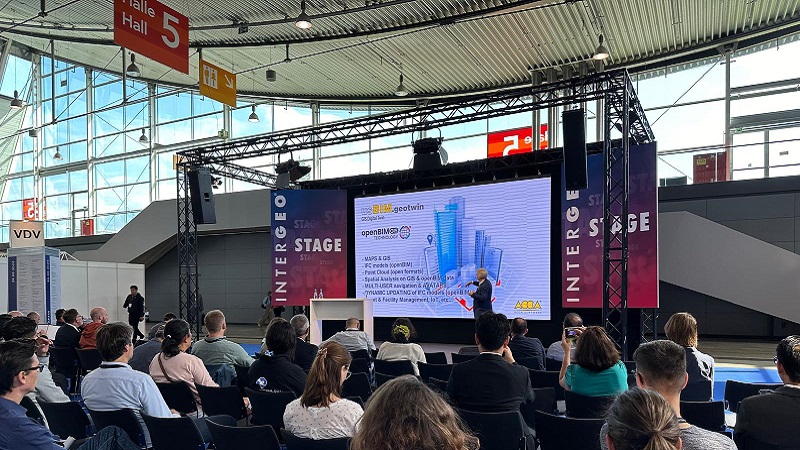
ACCA software Conference | Intergeo


