
BIM in Port Infrastructure: Transforming Design and Management
Discover how BIM in port infrastructure improves design, management, and maintenance thanks to IFC 4.3, digital twin, and open BIM

Port and river infrastructures are among the most complex systems in civil engineering. Managing ports, navigable canals, and coastal works requires the coordination of multiple disciplines, the integration of large amounts of data, and continuous performance monitoring over time.
In this context, BIM in port infrastructure emerges as a digital approach that allows for the design, construction, and management of the work through a shared informational model. This model integrates geometries, technical data, and operational information, becoming the reference point for all phases of the life cycle.
To support this transformation, the sector adopts infrastructure information modeling (I-BIM), which enables coherent data organization and improves collaboration among all involved parties.
A key role is played by the IFC (Industry Foundation Classes) standard. With the introduction of IFC 4.3 and the IfcPortsAndWaterwaysDomain schema, it is possible to specifically model ports and hydraulic infrastructures. This allows structuring and sharing information in an open and interoperable format, enhancing design, management, and maintenance.
In this article, we will analyze what **BIM in port infrastructure** is, what advantages it offers, and how it is applied through the IFC standard and the most advanced digital technologies such as:
- a software to convert BIM models from IFC 2×3 to IFC 4.3, the latest version of the IFC standard developed to also support infrastructural modeling;
- an IFC editor, which allows you to view, manage, and modify your infrastructural IFC models directly online, regardless of the BIM Authoring software used to create them.
Contents
- What is BIM in port infrastructure
- Practical Applications of BIM in Port Infrastructure
- The role of IFC in the application of BIM in port infrastructure
- Adoption of the IFC 4.3 standard in port BIM workflows
- IfcPortsAndWaterwaysDomain: the IFC schema for port infrastructure
- Digital Twin, IoT, and GIS in port infrastructure
- Maintenance planning and lifecycle management of port resources with BIM
- Sustainability and smart ports: the role of BIM in port infrastructure of the future
- FAQ on BIM in port infrastructure
What is BIM in port infrastructure
BIM in port infrastructure is a digital approach that allows for the design, construction, and management of ports and maritime works through three-dimensional informational models enriched with technical, functional, and operational data.
The Building information modeling (BIM) is not limited to geometric representation. It integrates structured information about infrastructure elements, such as materials, performance, maintenance, and operational status.
The BIM model can be derived from existing drawings, laser scanner surveys, or GIS data, and includes all elements of the infrastructure, such as docks, breakwaters, terminals, plants, and equipment. The georeferencing of the model allows for consistent and reliable management of information in real space.
The adoption of BIM offers tangible benefits across all phases of the life cycle:
- greater collaboration: all information resides in a single model accessible to designers, managers, and operators, with improved coordination among disciplines;
- reduction of design errors: the model allows for preventive checks and simulations, reducing clashes and modifications during construction;
- optimization of management: the digital model supports operational planning and improves resource management;
- predictive maintenance: the integration between BIM, sensors, and digital twin improves monitoring of infrastructures and enables more effective planning of interventions;
- greater sustainability: data analysis allows for the optimization of consumption, materials, and environmental impacts.
BIM also serves as the foundation for the integration with other informational approaches, such as BrIM Bridge Information Modeling, which is used for the management of bridges in port areas and along connected transport networks.
Thanks to these advantages, BIM enables port managers to improve operational efficiency, reduce management costs, and increase the resilience of infrastructures in the long term.
Practical Applications of BIM in Port Infrastructure
BIM is applicable in all operational phases of port infrastructure. It allows for integrated management of design, construction, and operation, improving activity control and decision-making quality.
The main applications include:
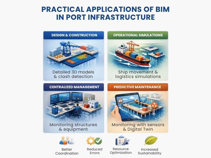
- design and construction: BIM enables the creation of detailed 3D models of docks, terminals, warehouses, and maritime works. The model allows for interference checks, constraint analysis, and evaluation of solutions before construction. This reduces errors, variations, and unexpected costs;
- planning and operational simulation: the BIM model allows for the simulation of port operations, such as ship movements, crane usage, and logistics flow management. These simulations help identify critical issues and optimize space and activities. They can also include emergency scenarios and risk analysis;
- centralized management of infrastructure: BIM provides a unique informational environment that integrates geometric, technical, and operational data. Port managers can access up-to-date information about structures and facilities, improving activity planning. This approach reduces downtime and increases safety;
- predictive maintenance and performance management: the integration between BIM, Digital Twin and IoT sensors enables continuous monitoring of infrastructure conditions. The collected data allows interventions to be planned before failures or degradation occur. This reduces maintenance costs and increases the useful life of the works. An example is the port of A Coruña, which uses BIM for maintenance management;
- life cycle analysis of infrastructure: BIM allows for the management of information throughout the life cycle, from design to decommissioning. The model includes data on materials, performance, and intervention history. This approach enables more accurate technical, economic, and environmental assessments and supports sustainable management strategies.
Applications of BIM in port infrastructure
The role of IFC in the application of BIM in port infrastructure
To function effectively, BIM requires a standard that allows for the exchange of data between different software and actors. This role is fulfilled by IFC (Industry Foundation Classes), an open format that enables the sharing of informative models in an interoperable way.
Unlike proprietary formats, IFC ensures that information remains accessible and usable over time, regardless of the software adopted. This aspect is crucial in port projects, where different stakeholders collaborate with various tools and expertise.
With the IFC 4.3 version, the standard has been extended to infrastructure. It includes specific tools for modeling roads, bridges, railways, and maritime works.
In the port context, IFC 4.3 allows for the structured representation of elements such as docks, piers, channels, and protection works, integrating geometric and informative data into a single consistent model.
Structure of the IFC standard
IFC is based on a structure organized into conceptual levels, each with a specific function:
- Resource Layer: contains the basic definitions and essential resources used by other levels;
- Core Layer: includes general entities common to all domains, equipped with unique identifiers and traceability information;
- Interoperability Layer: defines entities usable across multiple disciplines, such as shared products and processes;
- Domain Layer: collects the specific schemas for each infrastructure sector.
Within the Domain Layer falls the schema IfcPortsAndWaterwaysDomain, dedicated to port and river infrastructures. This schema extends the functionalities of IFC and allows for the structured modeling of typical elements in the maritime context.
The use of IFC in port projects is essential in ports:
- enables data exchange between different software;
- ensures continuity and access to information over time;
- supports collaboration among all project stakeholders;
- allows for the management of infrastructure throughout its entire life cycle.
Thanks to IFC 4.3, BIM becomes a structured tool for the digital management of port infrastructure.
Adoption of the IFC 4.3 standard in port BIM workflows
The adoption of IFC 4.3 is not just about the export of the model, but the entire informational process. The model must be structured from the outset according to interoperable logic, with consistent classifications, defined properties, and correct relationships between elements.
In port workflows, IFC 4.3 enables:
- structuring of elements: organizing docks, piers, channels, and protection works through dedicated entities;
- data management: associating technical, functional, and maintenance data with objects;
- traceability of information: ensuring traceability of changes and unique identification of elements;
- integration with other systems: facilitates the connection with management platforms and asset management systems.
Migration from IFC 2×3 to IFC 4.3
A central aspect concerns the migration of existing models. Many projects still use IFC 2×3, which does not fully support infrastructural modeling. The use of conversion tools to IFC 4.3 enables the updating of models and alignment with new informational requirements.
Effective adoption of the standard also requires clear operational guidelines. It is necessary to define:
- levels of detail and information (LOD and LOI);
- classification criteria consistent with the port domain;
- validation procedures for the IFC model before delivery.
IfcPortsAndWaterwaysDomain: the IFC schema for port infrastructure
IfcPortsAndWaterwaysDomain is the IFC schema dedicated to the digital modeling of port infrastructure and waterways. It is part of the Domain Layer and introduces dedicated entities to structurally represent elements typical of the maritime context.
This schema allows for the description of ports and hydraulic works through consistent informational models, supporting all phases of the lifecycle: from design to operational management.
Among the main features of IfcPortsAndWaterwaysDomain is the ability to model complex and diverse concepts, organized into three categories:
- complex types: includes the representation of a wide range of port and river infrastructure such as cargo ports, passenger terminals, marinas, shipyards, offshore bases, canal networks, and locks;
- types of structures: covers a broad spectrum of fundamental structures for port operations such as breakwaters, embankments, locks, sluice gates, dry docks, floating docks, piers, quays, anchorages, navigable channels, and intermodal areas, ensuring a coherent representation of the fundamental elements for management and maintenance;
- maritime products and components: includes specific details on essential products and components such as cranes, sluice gates, mooring devices, buoys, lights and signage, fenders, and bollards, which are essential for operations and safety.
Thanks to this articulation, IfcPortsAndWaterwaysDomain provides a comprehensive framework for the digital management of port and hydraulic infrastructure and promotes interoperability and data consistency.
Applications of IfcPortsAndWaterwaysDomain in port planning and design
IfcPortsAndWaterwaysDomain supports the planning and design of port infrastructure through structured and information-rich digital models.
In the preliminary phases, it allows for the development of functional models that integrate data such as indicative dimensions, spatial constraints, and operational requirements. This enables the analysis of layouts, verification of compatibility with the context, and comparison of different design solutions.
In the detailed design, the model is enriched with more precise technical information and relationships between elements. This improves data consistency and facilitates coordination among disciplines.
Advantages of using IfcPortsAndWaterwaysDomain
The adoption of IfcPortsAndWaterwaysDomain in the context of BIM offers numerous benefits that enhance both the design and management of maritime infrastructure. The main advantages include:
- centralization of information: the schema allows for the organization of all project-related data in a single digital model, ensuring consistency and accessibility. This reduces fragmentation among disciplines and facilitates interdisciplinary collaboration among architects, engineers, and port operators;
- interoperability: thanks to the standardization of data in the IFC format, the schema eliminates barriers between different software, allowing for smooth information exchange between platforms;
- geometric and informative integration: three-dimensional models in IFC format not only represent the geometry of the infrastructure but also include technical and functional data that support in-depth analyses, such as structural simulations, environmental checks, and economic evaluations;
- project optimization: through the detailed representation of key elements, such as quays, navigable channels, and intermodal terminals, it is possible to analyze different design alternatives and assess their economic, operational, and environmental impact;
- risk reduction: preliminary models contain fundamental information, such as indicative dimensions and functional constraints, which help identify and resolve issues before the construction phase;
- support for management and maintenance: the schema allows for enriching models with data related to materials, maintenance histories, and operational requirements, facilitating the management of the infrastructure throughout its lifecycle;
- sustainability and innovation: the integration of environmental data into the model allows for the design of resilient and environmentally friendly infrastructures, while the adoption of technologies such as digital twins facilitates monitoring and performance optimization.

Advantages of IfcPortsAndWaterwaysDomain
Challenges and solutions in implementation
Despite the numerous advantages, the adoption of the IfcPortsAndWaterwaysDomain presents some critical issues related to technical complexity, standardization, and the transition from traditional methods to digital workflows. The main challenges involve the following aspects:
- interoperability between software: many tools use proprietary formats that are not compatible with the IFC standard, resulting in difficulties in data exchange and integration. To overcome this limitation, it is necessary to develop IFC-compatible software, promote shared protocols among providers, and use standardized object libraries;
- required technical skills: managing information models requires specific knowledge and a shift from methods based on two-dimensional drawings. It is therefore essential to invest in training professionals, provide operational guidelines, and adopt more accessible software tools;
- lack of global standardization: regulatory and operational differences between countries can limit uniform adoption of the scheme. Collaboration among standardization bodies, public entities, and industry associations allows for the definition of common guidelines and ensures greater consistency;
- initial adoption costs: implementation requires investments in technology and training. A gradual approach, the use of conversion tools, and employing open-source solutions help reduce the initial impact;
- resistance to change: some operators are tied to traditional methods and show difficulties in adopting new digital tools. The dissemination of case studies, stakeholder involvement, and demonstration of operational benefits favor a more effective transition.
Overcoming these challenges requires collaboration among designers, software developers, regulatory bodies, and industry stakeholders. However, adopting the IfcPortsAndWaterwaysDomain allows for tangible benefits that justify the initial investment and support the digitization and innovation of maritime infrastructure in the long term.
The future of the IfcPortsAndWaterwaysDomain in BIM
The IfcPortsAndWaterwaysDomain represents a significant step in the evolution of BIM applied to maritime infrastructure. Its development will be closely linked to the dissemination of open standards and integration with new digital technologies.
Main developments include:
- integration with digital twins, enabling the creation of digital copies of port infrastructures useful for monitoring performance, planning maintenance, and improving operational management;
- improvement of interoperability between BIM platforms, which facilitates data exchange among different software, enhances collaboration between involved parties, and ensures greater information continuity;
- extension of the schema to new types of infrastructure, allowing support for the evolution of operational needs and the introduction of new technological solutions;
- international dissemination of the standard, which depends on collaboration among organizations, public entities, and private operators and contributes to making BIM increasingly central in the design and management of port infrastructures.
The evolution of the IfcPortsAndWaterwaysDomain will contribute to making the management of maritime infrastructure more efficient, digital, and lifecycle-oriented.
Digital Twin, IoT, and GIS in port infrastructure
The integration of BIM, Digital Twin, IoT, and GIS allows for a more dynamic, data-driven management of port infrastructure. These technologies transform the BIM model into an operational tool, used not only for design but also for monitoring and real-time management.
Digital Twin: digital replica of the infrastructure
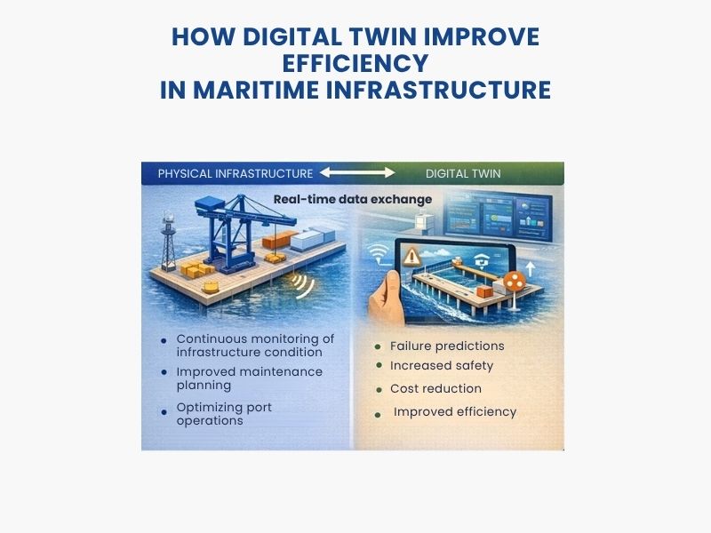
The digital twin is a dynamic digital representation of the physical infrastructure, updated through real data.
In the port context, it allows for:
- monitoring the condition of infrastructures in real-time;
- analyzing performance over time;
- planning maintenance interventions more accurately;
- simulating operational and management scenarios.
The digital twin is based on the BIM model, which provides the informational structure on which to integrate data from the field.
Digital Twin for the efficiency of maritime infrastructure
IoT: real-time monitoring of port infrastructure
IoT (Internet of Things) technologies allow for data collection directly from infrastructures through sensors installed on structural elements and systems.
This data can pertain to:
- deformations, vibrations, and structural loads;
- conditions of materials and degradation;
- utilization of infrastructures and operational flows.
Integrating with BIM allows for updating the digital model with real information, improving the reliability of analyses and decisions.
GIS: integration with territorial context in port planning and management
The GIS (Geographic Information System) enables the integration of the BIM model with large-scale geographical information.
This allows for:
- analyzing the relationship between port infrastructures and the territory;
- assessing environmental, coastal, and urban planning constraints;
- supporting territorial planning and infrastructure development;
- coordinating activities between port authorities and local authorities.
Maintenance planning and lifecycle management of port resources with BIM
BIM allows for more structured management of port infrastructures throughout the lifecycle. The information model becomes a centralized database, used to plan, monitor, and optimize operational activities.
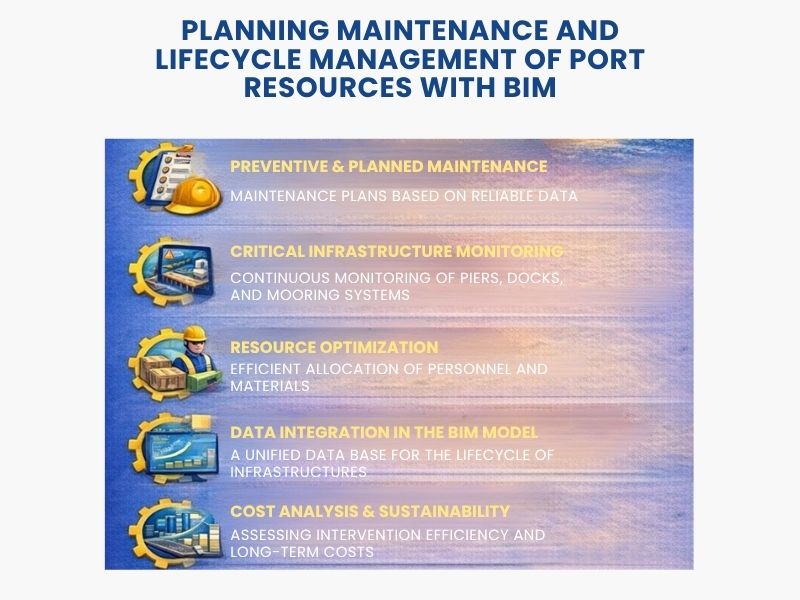
Using BIM for the management of port resources enables:
- planning for preventive and scheduled maintenance interventions based on reliable and up-to-date data;
- monitoring the condition of critical elements, such as docks, piers, locks, and mooring systems, with constant updates on their functional status;
- optimizing the allocation of human and material resources, avoiding duplicated or unnecessary interventions;
- integrating lifecycle information of infrastructures into the digital model, creating a unified database for designers, managers, and operators;
- supporting economic and operational analyses to evaluate the efficiency of interventions and the sustainability of long-term costs.
Maintenance and lifecycle management of port resources with BIM
Sustainability and smart ports: the role of BIM in port infrastructure of the future
BIM contributes to the transition towards more sustainable and efficient management models in port infrastructure. The integration of technical, environmental, and operational data allows for the assessment of the performance of works throughout their life cycle.
The use of BIM enables support for design and management decisions focused on sustainability.
In particular, it allows to:
- assess the environmental impact of works, considering factors such as coastal erosion, water flows, and biodiversity;
- optimize the use of materials and resources, reducing waste and emissions;
- simulate scenarios related to climate change, such as rising sea levels or extreme weather events;
- monitor environmental performance over time through updated data.
The concept of smart port is based on the integration of digital technologies to improve the efficiency, safety, and sustainability of port operations.
In this context, BIM represents a central information platform that allows to:
- coordinate port operations, optimizing the flow of goods, vehicles, and people;
- integrate data from digital systems to support quick and informed decisions;
- simulate complex operational scenarios and identify critical issues;
- improve coordination among public entities, private operators, and stakeholders.
The adoption of BIM in smart ports not only increases operational efficiency but also creates the conditions for proactive and resilient management of port infrastructure, fostering the development of safer, more sustainable, and globally competitive ports.
To fully exploit the potential of BIM applied to maritime infrastructure, it is essential to have the right tools. A conversion software from IFC 2×3 to IFC 4.3 will allow you to work with the latest version of the standard, designed to support infrastructure modeling. Moreover, with an IFC editor, you can manage, visualize, and modify your infrastructure models easily and directly, ensuring maximum flexibility regardless of the authoring software used for creation. Try these tools now and start transforming your projects today with the power of the IFC standard. Make your work more efficient and future-oriented in the industry!
Read the in-depth articles: “openBIM standards” and “GeoAI”
FAQ on BIM in port infrastructure
What is BIM in port infrastructure?
BIM in port infrastructure is a digital approach that allows the design, construction, and management of ports and maritime works through 3D informational models. These models not only describe the geometry of the work but also integrate technical, functional, and operational data useful throughout the lifecycle of the infrastructure.
What is the purpose of BIM in ports?
BIM serves to improve information management and coordination among the parties involved. In the port sector, it supports design, operational simulation, maintenance, performance monitoring, and planning of interventions throughout the lifecycle of the work.
What advantages does BIM in port infrastructure offer?
Among the main advantages are increased collaboration among designers, managers, and operators, reduced design errors, more efficient resource management, support for predictive maintenance, and greater sustainability through the analysis of technical and environmental data.
Why is the IFC standard important in port projects?
The IFC is important because it allows data to be exchanged between different software and actors in an open and interoperable format. In port projects, this means being able to share information more reliably, keep data accessible over time, and support collaboration among all involved parties.
What is IfcPortsAndWaterwaysDomain?
IfcPortsAndWaterwaysDomain is the IFC schema dedicated to the digital modeling of port infrastructure and waterways. It is part of the Domain Layer and introduces specific entities to represent ports, hydraulic works, maritime components, and other typical elements of the port context in a structured way.
How is BIM used in the maintenance of port infrastructure?
BIM is used as a centralized database to plan and manage maintenance interventions. It allows for monitoring the condition of critical elements, organizing preventive and scheduled maintenance, optimizing resource use, and integrating information collected over time into the model.
What is the role of Digital Twin, IoT, and GIS in ports?
These technologies extend the capabilities of BIM. The Digital Twin allows for creating a dynamic digital replica of the infrastructure, the IoT collects real-time data through sensors, and the GIS integrates the model with geographical and territorial information. Together they enable more dynamic, up-to-date, and monitoring-oriented management.
How does BIM support sustainability and smart port?
BIM helps assess the environmental impact of the works, optimize materials and resources, simulate climate change-related scenarios, and monitor environmental performance over time. In smart ports, it also acts as a central informational platform to coordinate operations, integrate digital data, and improve efficiency, safety, and resilience.


